Jozankei Experimental Watershed
Summary
- The Jozankei Experimental Watershed is located in the national forest near Sapporo, within the Toyohira River basin, a tributary of the Ishikari River.
- This experimental watershed was established in 1987 to conduct forest hydrological research in a snowy cold region of Hokkaido prefecture with a natural mixed forest.
- This experimental watershed has two small watersheds: the Shigure-Ichinosawa (1.998 ha) and Shigure-Ninosawa (6.071 ha). When this experimental watershed was first established, a pair catchment experiment was planned, but the experiment was terminated for various reasons. There is also no plan for cutting down trees in the future.
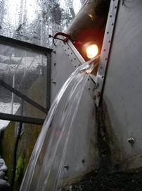
- Problems such as leakage of water from the gauging weir and freezing of flowing water during winter occurred at the beginning. Therefore, observation throughout the year was started in 1991 and still continues.
Data period
| Item |
Daily precipitation |
Daily runoff |
|
| Data source〵Location |
Meteorological station |
Shigure-ichinosawa |
Shigure-ninosawa |
| 1 |
1991-2001 |
1991-2001 |
1991-2001 |
| 2 |
2002-2007 |
2002-2007 |
2002-2007 |
| 3 |
2008-2012 |
2008-2012 |
2008-2012 |
| 4 |
2013-2017 |
2013-2017 |
2013-2017 |
Data source
- Toshio ABE, Katsumi YAMANOI, Tomoki SAKAMOTO, Yuichiro NAKAI, Kenzo KITAMURA, Satoru SUZUKI, Akira SHIMIZU (2010) Report of hydrological observations at the Jozankei Experimental Watershed (January 1991 to December 2001), Bulletin of FFPRI, 9(2), 75-102.
- Toshio ABE, Katsumi YAMANOI, Kenzo KITAMURA, Yuichiro NAKAI, Satoru SUZUKI, Tomoki SAKAMOTO, Masayoshi TAKAHASHI (2011) Report of hydrological observations at the Jozankei Experimental Watershed (January 2002 to December 2007), Bulletin of FFPRI, 10 (2), 109-129.
- Toshio ABE, Katsumi YAMANOI, Yasuko MIZOGUCHI, Kenzo KITAMURA (2014) Report of hydrological observations at Jozankei Experimental Watershed (January 2008 to December 2012), Bulletin of FFPRI, 13 (4), 207-223.
- Tatsuhiko NOBUHIRO, Katsumi YAMANOI, Yasuko MIZOGUCHI, Toshio ABE Report of hydrological observations at Jozankei Experimental Watershed (January 2013 through December 2017), Bulletin of FFPRI, in press.
Details on Experimental Watershed
| Location | Jozankei, Minami-ku, Sapporo, Hokkaido | Topography |
| River system | Ishikari River system (Toyohira River Basin) |

|
| Latitude | 42° 59'N | |
| Longitude | 141° 10'E | |
| Altitude (m) | 305* |
| Shigure-ichinosawa | Shigure-ninosawa | |
| Area (ha) | 1.998 | 6.071 |
| Altitude (m) | 311 - 441 | 319 - 477 |
| Geology | Quartz-porphyry (Miocene epoch, Neogene period) | |
| Soil | Brown forest soil | |
| Vegetation | Natural mixed forest (Abies sachalinensis, Quercus mongolica, Tilia japonica, Acer pictum, Cercidiphyllum japonicum, etc.) | |
| Annual mean temperature (゚C) | 5.8** | |
| Annual precipitation (mm) | 1292** | |
Photos of Experimental Watershed
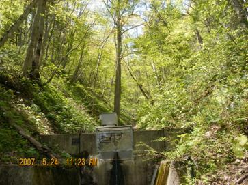
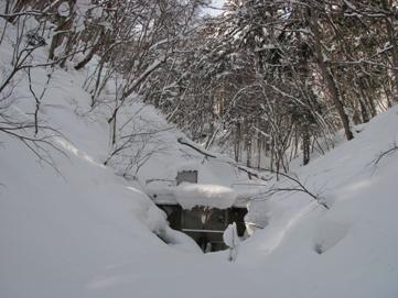
| Just after foliation in Shigure-Ichinosawa Watershed | During the coldest period in Shigure-Ninosawa Watershed | 60°V-notch and heat lamp for freeze-proofing |
|
|
|
| Click on a photo to enlarge. | ||
Contact:
Cold Region Environment Conservation Group,
Hokkaido Research Center,
Forestry and Forest Products Research Institute, Japan
Hokkaido Research Center,
Forestry and Forest Products Research Institute, Japan