Kahoku Experimental Watershed
Summary
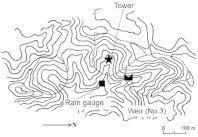
- The Kahoku Experimental Watershed is located in the upstream area of the Kikuchi River.
- Measurement was started to establish the suitable plan for conservation of forested watershed and to understand its hydrological functions in warm temperate region, northern part of Kyushu Island.
- Water discharge measuerement has been conducted since 1992.
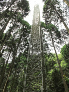
- A 50-m-high meteorological observation tower was constructed in 1999, at the center of No.2 sub-watershed to evaluate H2O and CO2 fluxes.
Data period
| Item |
Monthly precipitation |
Monthly runoff |
| Data source〵Location |
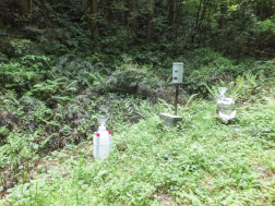
Rain gauge station |
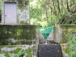
No.3 sub-watershed |
| ※ |
2000-20081 | 2000-20081 |
Data source
- SHIMIZU Takanori, KUMAGAI Tomo’omi, KOBAYASHI Masahiro, TAMAI Koji, IIDA Shin’ichi, KABEYA Naoki, IKAWA Reo, TATEISHI Makiko, MIYAZAWA Yoshiyuki, SHIMIZU Akira (2015) Estimation of annual forest evapotranspiration from a coniferous plantation watershed in Japan (2): Comparison of eddy covariance, water budget and sap-flow plus interception loss, Journal of Hydrology 522:250-264.
Details on Experimental Watershed
| Location | Yamaga City, Kumamoto Pref. | Topography |
| River system | Kikuchi River system |
|
| Latitude | 33° 08'N | |
| Longitude | 130° 43'E | |
| Altitude (m) | 140* |
| Stream No.3 | |
| Area (ha) | 3.69 |
| Altitude (m) | 157 - 255 |
| Geology | Crystal schist |
| Soil | Brown forest soil |
| Vegetation | Planted forest of Japanese cedar and cypress |
| Annual mean temperature (゚C) | 15.3** |
| Annual precipitation (mm) | 2138** |
Photos of Experimental Watershed
| Weir of No.3 sub-watershed | Rain gauge station | Observation tower |
|
|
|
| Click on a photo to enlarge. | ||
Contact:
| Takanori Shimizu |
Department of Disaster Prevention, Meteorology and Hydrology,
Forestry and Forest Products Research Institute, Japan
| Naoki Kabeya |  |
Kyushu Research Center,
Forestry and Forest Products Research Institute, Japan