Kamabuchi Experimental Watershed
Summary
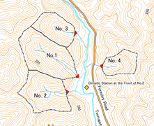
- The Kamabuchi Experimental Watershed is located in the northern part of Yamagata Prefecture, in the head water area of the secondary tributary of the Sake river which flows into the midstream of Mamuro river, a tributary of the Mogami River.
- Hydrological observations were started in order to elucidate the relationship between forest cover and water runoff in a snowy cold region.
- Observations began in 1939 at two watersheds called the No. 1 with 3.060 ha and the No. 2 with 2.482 ha.
- Observations began in 1961 at another two watersheds named No. 3 with 1.540 ha and No. 4 with 1.117 ha.
- Observation of all watersheds within the Kamabuchi Experimental Watershed is continuing today, although observations at No. 4 were temporally halted at 2000.
Data period
| Item |
Daily precipitation |
Daily runoff |
|||||
| Data source〵Location |
Main climatic station |
Front of watershed No.2 |
Side of office |
No.1 |
No.2 |
No.3 |
No.4 |
| 1 |
1939-1958 |
1940-1958 |
1939-1958 |
1939-1958 |
|||
| 2 |
1959-1978 |
1959-1978 |
1959-1978 |
||||
| 3 |
1979-1993 |
1979-1993 |
1979-1993 |
||||
| 4 |
1998.5-2000 |
1994-1998.4 |
1994-2000 |
1994-2000 |
|||
| 5 |
1961-2000 |
1961-2000 |
|||||
| 6 |
2001-2005 |
2001-2005 |
2001-2005 |
2001-2005 |
|||
| 7 |
2006-2010 |
2006-2010 |
2006-2010 |
2006-2010 |
|||
| 8 |
2011-2016 |
2011-2016 |
2011-2016 |
2011-2016 |
2011-2016 |
||
Data source
- Government Forest Experiment Station (1961) 2. Yamagata Experimental Site Tohoku Branch Station (Kamabuchi Experimental Watershed), Statistical report of hydrological observation at forested experimental basins (Daily precipitation and discharge volume), p.66-118 (in Japanese).
- Yamagata Experiment Site, Tohoku Branch Station (1980) Statistical Reports of Hydrological Observation at Kamabuchi Experimental Watershed No.1 and No.2 Experimental watersheds (January, 1959 - December, 1978), Bulletin of Forestry and Forest Products Research Institute, 311, 129-188 (in Japanese).
- HOSODA, I., DAIMARU, H., MURAKAMI, W., KITADA, M., and SAITO, T. (1999) Statistical Report of Hydrological Observation at Kamabuchi Experimental Watershed ―No.1 and No.2 Experimental Watersheds― (January, 1979 to December, 1993), Bulletin of Forestry and Forest Products Research Institute, 376, 1-52 (in Japanese with English summary).
- HOSODA, I., and MURAKAMI, W. (2006) Hydrological Observation Reports of the Kamabuchi Experimental Watershed -No.1 and No.2 Experimental Watersheds- (January 1994 to December 2000), Bulletin of Forestry and Forest Products Research Institute, 398, 99-118 (in Japanese with English abstract).
- HOSODA, I., and MURAKAMI, W. (2007) Hydrological Observation Reports of the Kamabuchi Experimental Watershed -No.3 and No.4 Experimental Watersheds- (January 1961 to December 2000), Bulletin of Forestry and Forest Products Research Institute, 404, 163-213 (in Japanese with English abstract).
- HOSODA, I., MURAKAMI, W., and NOGUCHI, S. (2009) Hydrological Observation Reports of the Kamabuchi Experimental Watershed -No.1, No.2 and No.3 Experimental Watersheds- (January 2001 to December 2005), Bulletin of Forestry and Forest Products Research Institute, 410, 51-70 (in Japanese with English abstract).
- NOGUCHI, N., MURAKAMI, W., and ABE, T., HOSODA, I. (2023) Hydrological observation reports of the Kamabuchi Experimental Watershed -No. 1, No. 2, No. 3 experimental watersheds- (January 2006 through December 2010), Bulletin of Forestry and Forest Products Research Institute, 464, 275-303 (in Japanese with English abstract).
- KUBOTA, T., NOGUCHI, N., and ABE, T. (2023) Statistical report of hydrological data from Kamabuchi Experimental Watershed -No. 1, 2, 3 and 4 experimental watersheds (January, 2011 to December, 2016) -, 464, 305-355 (in Japanese with English abstract).
Details on Experimental Watershed
| Location | Kamabuchi, Mamurogawa Town, Mogami Country, Yamagata Prefecture, Japan | Topography |
| River system | Mogami River system (Mamurogawa Basin) |
|
| Latitude | 38° 56'N | |
| Longitude | 140° 15'E | |
| Altitude (m) | 160* |
| No.1 | No.2 | No.3 | No.3 | |
| Area (ha) | 3.060 | 2.482 | 1.540 | 1.117 |
| Altitude (m) | 162 - 252 | 166 - 248 | 172 - 244 | 177 - 244 |
| Geology | Tuff and shaley tuff | |||
| Soil | Brown forest soil | |||
| Vegetation | Deciduous broad-leaved forest with Fagus crenata, Quercus crispula, Quercus serrata, etc., and plantation of Cryptomeria japonica | |||
| Annual mean temperature (゚C) | 10.0** | |||
| Annual precipitation (mm) | 2625.1** | |||
Photos of Experimental Watershed
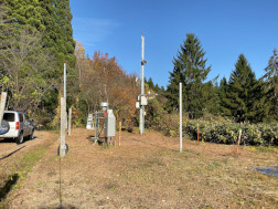
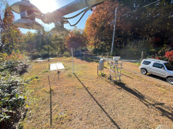
| Main climatic station | No. 1 watershed |
|
|
| Click on a photo to enlarge. | |
Contact:
Forest Environment Group, Tohoku Research Center,
Forestry & Forest Products Research Institute, Japan.
Forestry & Forest Products Research Institute, Japan.