Sarukawa Experimental Watershed
Summary
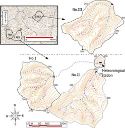
- The Sarukawa Experimental Watershed is located in the upstream area of the Oyodo river, in the southern part of Miyazaki Prefecture, Kyushu, Japan.
- Observations were started in order to investigate forest hydrology and water conservation in a warm-temperate region. The Experimental Watershed has three small watersheds with different forest types.
- For purposes of research, forests in the No. I and No. III watersheds were clear-cut in 1965-1966, and part of forest in the No. ćUwatershed was cut in 1982.
- Hydrological observations started in 1959. The results of observations from this experimental watershed were gradually released in the years following 1967, when standard observations were started. Observation is continuing today.
Data period
| Item |
Daily precipitation |
Daily runoff |
||
| Data source〵Location |
Meteorological station |
No.I |
No.II |
No.III |
| 1 |
1967-1976 |
1967-1976 |
1967-1976 |
1967-1976 |
| 2 |
1977-1986 |
1977-1986 |
1977-1986 |
1977-1986 |
| 3 |
1987-2000 |
1987-2000 |
1987-2000 |
1987-2000 |
| 4 |
2001_2005 |
2001_2005 |
2001_2005 |
2001_2005 |
Data source
- Forest Influences Unit, Kyushu Branch Stationüi1982üjStatistical Report of Hydrological Observation at SARUKAWA Experimental Watershed (January, 1967 to December, 1976), Bulletin of Forestry and Forest Products Research Institute, 317, 147-190 (in Japanese).
- Miyuki TAKESHITA, Akira SHIMIZU and Yasuo MIYABUCHIüi1996üjStatistical Report of Hydrological Observation at SARUKAWA Experimental Watershed (January, 1977 to December, 1986), Bulletin of Forestry and Forest Products Research Institute, 370, 31-75 (in Japanese).
- Akira SHIMIZU, Yasuo MIYABUCHI, Takanori SHIMIZU, Yasuhiro OGAWA, Hiromu DAIMARU, Tamotsu SATO and Miyuki TAKESHITAüi2008üjStatistical report of hydrological observations at the Sarukawa experimental watershed (January 1987 to December 2000), Bulletin of Forestry and Forest Products Research Institute, 7(1), 13-65 (in Japanese with English abstract).
- Shiho ASANO, Akira SHIMIZU, Naoki KABEYA, Hiroaki HAGINO and Koji TAMAIüi2011üjStatistical report of hydrological observations at the Sarukawa experimental watershed (January, 2001 to December, 2005), Bulletin of Forestry and Forest Products Research Institute, 10(1), 49-71 (in Japanese with English abstract).
Details on Experimental Watershed
| Location | Yoreshi, Takaoka Town, Miyazaki City, Miyazaki Prefecture, Japan | Topography |
| River system | Oyodo River system |
|
| Latitude | 31° 51'N | |
| Longitude | 131° 13'E | |
| Altitude (m) | 230* |
| No.I | No.II | No.III | |
| Area (ha) | 6.6 | 9.2 | 8.2 |
| Altitude (m) | 263 - 370 | 232 - 358 | 202 - 288 |
| Geology | Shimanto group (Shale including sandstone, limestone and conglomerate) | ||
| Soil | Brown Forest Soil (BAüABCüABD) | ||
| Vegetation | Plantation of conifer (Chamaecyparis obtusa) and broad-leaved forest (Morus australis and Machilus japonica) | Broad-leaved secondary forest (Castanopsis cuspidate, Lithocarpus edulis, Quercus stenophylla and Distylium racemosum) | Plantation of conifer (Cryptomeria japonica) and broad-leaved forest (Boehmeria spicata and Neolitsea aciculata) |
| Annual mean temperature (▀C) | 15.2** | ||
| Annual precipitation (mm) | 3078.3*** | ||
*** Average value for 1969-2000
Photos of Experimental Watershed
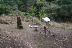
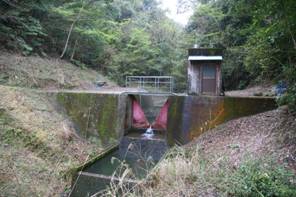
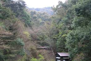
| Meteorological station | Hydrological observation station at No. II watershed | Forest at No. II watershed |
|
|
|
| Click on a photo to enlarge. | ||
Contact:
Environmental Conservation Research Group, Kyushu Research Center,
Forestry and Forest Products Research Institute, Japan.
Forestry and Forest Products Research Institute, Japan.