Takaragawa Experimental Watershed
Summary
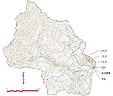
- The Takaragawa Experimental Watershed is located in the upstream area of Tone river, in the northern part of Gunma Prefecture, central Japan.
- Hydrological observations were started in order to estimate the relation between forest harvesting and water runoff, when natural forest dominated by beech was harvested in the headwater area in the Oku-Tone region in the upstream part of the Tone river. This area is a source of water for the Tokyo metropolitan area.
- Observations began in 1937 at two watersheds called the Honryu watershed with a 1,905.7ha area and the Shozawa watershed with a 117.9ha area.
- Observations began in 1957 at three smaller watersheds in the Shozawa watershed.
- Observation at the Honryu and Shozawa watersheds is continuing today.
Data period
| Item |
Daily precipitation |
Daily runoff |
||||
| Data source〵Location |
Main climatic station |
Honryu |
Shozawa |
Watersheds in Shozawa Watershed |
||
| No.1 |
No.2 |
No.3 |
||||
| 1 |
1937-1958 |
1937-1958 |
1937-1958 |
|||
| 2 |
1959-1977 |
1959-1977 |
1959-1977 |
|||
| 3 |
1957-1981 |
1957-1981 |
1957-1981 |
|||
| 4 |
1978-1990 |
1978-1990 |
1978-1990 |
|||
| 5 |
1991-2000 |
1991-2000 |
1991-2000 |
|||
| 6 |
2001-2010 |
2001-2010 |
2001-2010 |
|||
| 7 |
2011-2016 |
2011-2016 |
2011 |
|||
Data sources
- Government Forest Experiment Station (1961) Statical report of hydrological observation at forested experimental basins (Daily precipitation and discharge volume), p.119-171 (in Japanese).
- TAKARAGAWA Experimental Site, Flood Flow Control Unit, Forest Influences Division (1979) Statistical Reports of Hydrological Observation at TAKARAGAWA Experimental Watershed HONRYU and SHOZAWA Experimental watersheds (January, 1959 - December, 1977), Bulletin of Forestry and Forest Products Research Institute, 302, 97-154 (in Japanese).
- TAKARAGAWA Experimental Site and Flood Control Unit, Forest Influences Division (1984) Statistical Report of Hydrological Observation at TAKARAGAWA Experimental Watershed. No. 1, No. 2 and No. 3 Experimental Watersheds in SHOZAWA Experimental Watershed. (January, 1957-December, 1981), Bulletin of Forestry and Forest Products Research Institute, 327, 83-190 (in Japanese).
- FUJIEDA, M., SHlMIZU, T. (1994) Statistical Summary of Hydrological Data from TAKARAGAWA Experimental Basin-HONRYU and SHOZAWA Watersheds (January, 1978 to December, 1990), Bulletin of Forestry and Forest Products Research Institute, 368, 207-245 (in Japanese).
- KUBOTA, T., NOGUCHI S., SHIMIZU T., HOSODA, I., MURAKAMI S., KABEYA N., SHIMIZU A., ABE T., TSUBOYAMA Y., TAMAI K. (2020) Statistical report of hydrological data from TAKARAGAWA experimental watershed. - HONRYU and SHOZAWA watershed (January, 1991 to December, 2000), Bulletin of FFPRI, 19(2), 159-184.
- KUBOTA T., NOGUCHI S., SHIMIZU T., ABE T., SHIMIZU A., KABEYA N., NOBUHIRO T., IIDA S., TAMAI K., MURAKAMI S., SAWANO S., TSUBOYAMA Y. (2020) Statistical report of hydrological data from TAKARAGAWA experimental watershed. - HONRYU and SHOZAWA watershed (January, 2001 to December, 2010) -, Bulletin of FFPRI, 19(4), 373-400.
- TAMAI K., KUBOTA T., NOGUCHI S., SHIMIZU T., IIDA S., SAWANO S., NOBUHIRO T., ARAKI, M., TSUBOYAMA, Y. (2021) Statistical report of hydrological data from TAKARAGAWA experimental watershed. - HONRYU and SHOZAWA watershed (January, 2011 to December, 2016) -, Bulletin of FFPRI, 20(1), 49-67.
Details on Experimental Watershed
| Location | Fujiwara, Minakami Town, Tone County, Gunma Prefecture, Japan | Topography |
| River system | Tone River system |
|
| Latitude | 36° 51'N | |
| Longitude | 139° 01'E | |
| Altitude (m) | 805* |
| Honryu | Shozawa | Watersheds in Shozawa Watershed | |||
| No.1 | No.2 | No.3 | |||
| Area (ha) | 1905.7 | 117.9 | 6.5 | 4.4 | 5.2 |
| Altitude (m) | 805 - 1945 | 810 - 1380 | 816 - 1075 | 886 - 1102 | 924 - 1187 |
| Geology | Granite, Tuff, Diorite | ||||
| Soil | Brown forest soil, Podsol | ||||
| Vegetation | Natural forest with Fagus crenata, Quercus crispula, Acer pictum Thunb. subsp. mono (Maxim.), Magnolia obovata, Thujopsis dolabrata, Pinus parviflora, etc. and plantation of Larix kaempferi or Cryptomeria japonica. | ||||
| Annual mean temperature (゚C) | 8.3** | ||||
| Annual precipitation (mm) | 2134** | ||||
Photos of Experimental Watersheds
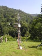
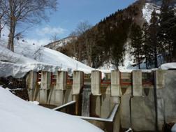
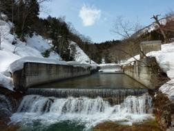
| Main climatic station | Shozawa | Honryu |
|
|
|
| Click on a photo to enlarge. | ||
Contact:
Forest Hydrology Laboratory,
Department of Disaster Prevention, Meteorology and Hydrology,
Forestry and Forest Products Research Institute, Japan
Department of Disaster Prevention, Meteorology and Hydrology,
Forestry and Forest Products Research Institute, Japan