Tsukuba Experimental Watershed
Summary
- The Tsukuba Experimental Watershed is located in the national forest, southeast of Mt. Tsukuba.
- This experimental watershed is the headwater of the Koise River, which is a tributary of the Tone River.
- In 1978, measurement was started at 3.76 ha watershed to understand the rainfall-runoff process and the effects of forest growth on the water balance.
- The measurement was temporally stopped for the period from 1993 to 2001, we restart it in 2002 and still continue.
Data period
| Item |
Daily precipitation |
Daily runoff |
| Data source〵Location |
Meteorological station |
Main stream |
| ※ |
1978-19871 | 1978-19871 |
| ※ |
2010-2017 | 2010-2017 |
Data source
- Water Resources Lab. and Flood Control Lab., Forest Environment Division (1993) Statistical Reports of Hydrological Observation at the TSUKUBA Experimental Watershed (May, 1978~December, 1987). Bulletin of Forestry and Forest Products Research Institute, 364, 125-168 (in Japanese).
Details on Experimental Watershed
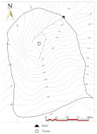
| Location | Ishioka City, Ibaraki Pref. | Topography |
| River system | Tone River system |
|
| Latitude | 36° 10'N | |
| Longitude | 140° 11'E | |
| Altitude (m) | 290 - 390 |
| Main stream | |
| Area (ha) | 3.76 |
| Altitude (m) | 290 - 390 |
| Geology | Biotite gneiss |
| Soil | Brown forest soil |
| Vegetation | Planted forest of Japanese cedar and cypress except for ridge area occupied by deciduous oak |
| Annual mean temperature (゚C) | 12.9* |
| Annual precipitation (mm) | 1429**, 1543.6* |
**Averaged value for 1972 - 1990 (Kabeya et al., 2014)
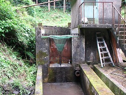
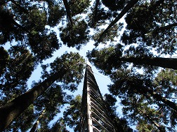
Photos of Experimental Watershed
| Weir of main stream | Observation tower | |
|
|
|
| Click on a photo to enlarge. | ||
Contact:
| Takanori Shimizu | |
| Shin'ichi Iida |  |
Department of Disaster Prevention, Meteorology and Hydrology,
Forestry and Forest Products Research Institute, Japan